
Shortly after posting the story about Larry Byrd pumping river water across property and parcel lines, I received a letter from an engineering firm justifying Byrd’s water transfers because both properties involved “are in the same watershed.” The letter was signed by someone describing herself as the “Principal Water Right Analyst” for an engineering firm out of Sacramento.
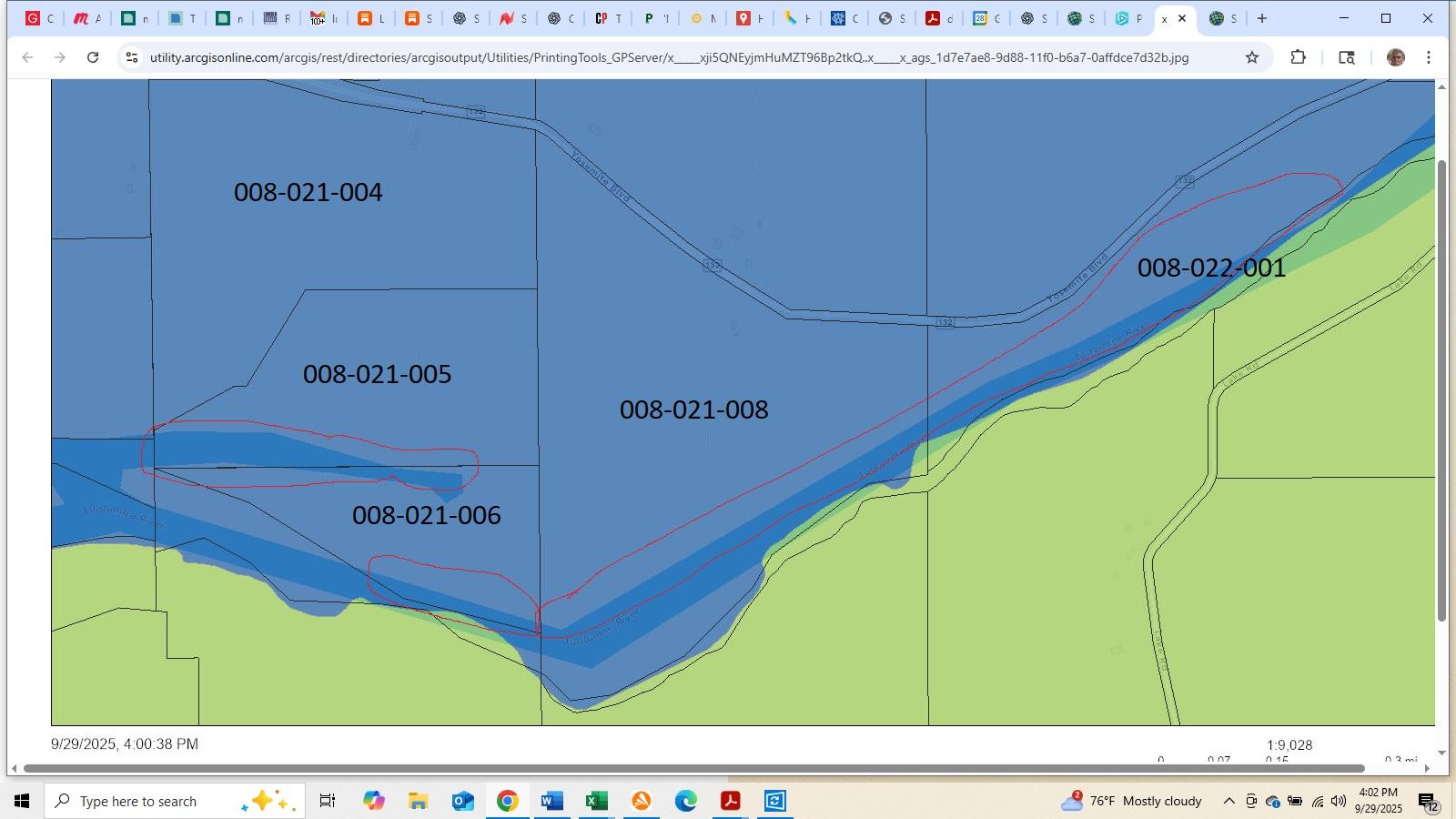
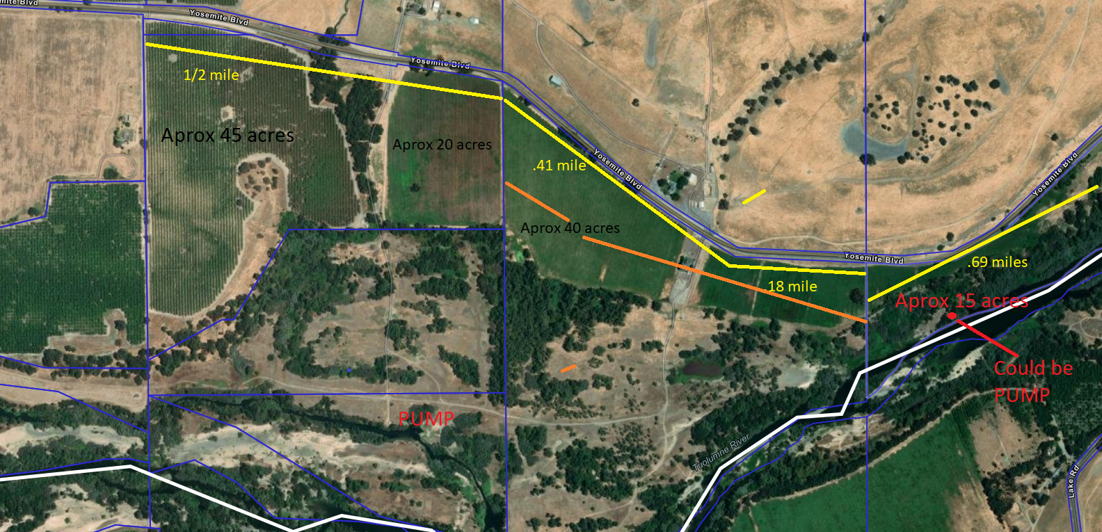
The foundation of her argument for transferring riparian water across property and parcel lines and increasing usage by as much as three and a half times boiled down to claims that the property on the receiving end of the transfer — hereafter known as the “Rairden” —has had riparian rights since the 1930s. The parcel number from which the Rairden rights originate is 08-21-06. It’s in southeastern Stanislaus County, east of Waterford and just a few miles west of La Grange.
At one time, that same Rairden property was divided into three parcels: 08-21-06, 08-21-05, and 08-21-04. It’s possible, in some cases, for riparian rights to be retained after parcel splits; the claim in this case is the rights were retained and apply to all three parcels. Had the rights not been retained, only 08-21-06 would have qualified for riparian rights. That parcel amounts to some 37 acres. Parcel 08-21-04 is approximately 90 acres; 08-21-05 is a bit under 60 acres. Parcel 08-21-06 is adjacent to the Tuolumne River. The other two parcels are not.
The point of diversion for the water transfer in question is on the Rodoni property, parcel number 08-22-01, over a mile upriver of the Rairden parcels. That property comprises approximately 50 acres. Historical use of riparian water for that property has been for pastureland.
The crux of the argument from Larry Byrd’s Principal Water Right Analyst is as follows:
“The creation of an assessor’s parcel in and of itself does not affect the riparian status of a property…In addition, diversion of Tuolumne River Water from the Rodoni Ranch pump for irrigation of the Rairden Property is considered part of a single watershed and does not alter the riparian right of the Rairden Property.”
The Principal Water Right Analyst’s argument would seem to be a classic case of ignoratio elenchi, otherwise known as “irrelevant conclusion,” or, more colloquially, “missing the point.”
The issue here is not about riparian water rights for the Rairden parcels in question, though it would be good to see documentation for the claim that parcels 005 and 004 were grandfathered in when they were split from the original point of diversion. Rather, the point is that river water has been pumped across property and parcel lines in clear violation of California Riparian Water Law.
Furthermore, the property in question, the Rodoni property (08-22-01), has riparian rights for only about 50 acres. In 2016, reported use of riparian water on that Rodoni parcel was 200 acre feet; that amount increased to 534 acre feet in 2019, then hit a high of 706 acre feet in 2022. Remember, the stated use of the water was for 50 acres of pastureland.
Meanwhile, over a mile away on the Rairden property, reported use for 2016 was 250 acre feet for the stated purpose of irrigating 40 acres of pastureland and 50 acres of almonds. By 2018, reported usage had burgeoned to 395 acre feet, just before dropping to 88 feet in 2019. The stated purpose for pumping riparian water onto that Rairden property was for 50 acres of almonds and 40 acres of pastureland.
Upstream on the Rodoni, reported usage for 2018 was 233 acre-feet. The 2019 drop on the Rairden, from 395 acre-feet the year before to 88 acre-feet, corresponded to the uptick on the Rodoni for that year (534 acre-feet).
Still, the numbers are bizarre. Combined usage for both properties in 2016 was 450 acre-feet. By 2022, combined usage had climbed to 863 acre-feet! Recorded usage for the Rodoni pump alone was 706 acre-feet. These figures were recorded after Byrd connected the two properties to a pipeline that facilitated pumping from parcel 08-22-01 on the Rodoni property to 08-21-04 on the Rairden property.
Most any use of water in California is based on the fundamental principles of “reasonable” and “beneficial.” Pumping river water across property and parcel lines in order to achieve a four-fold increase in acre-feet for the destination property is neither reasonable nor beneficial. In fact, for downstream users, it’s catastrophic, at least in principle.
Every parcel along the Tuolumne River is “in the same watershed.” Imagine upriver parcels trading water across parcel lines so that a few favored destinations horde all the water. Imagine selling and trading riparian water with the predictable results of more and more water in fewer and fewer hands.
Riparian water law is both defined and limited by the point of diversion for any given parcel or property. The fundamental rule is the parcel or property must touch the river. The application of river water on said property is limited by definition and law to the property adjacent to the river and no more. If this were not the case, people could transport water across property and parcel lines to an unlimited extent. The losers would be downstream users.
Downstream users from Larry Byrd’s Rodoni diversion point include farmers, urban users, Dos Rios State Park, the San Joaquin River National Wildlife Refuge, and too many other beneficiaries to count. All of them are “in the same watershed.”
Larry Byrd is a member of the Modesto Irrigation District’s Board of Directors. He’s currently under investigation for possible violations of water law on the upper portions of the same La Grange Ranch where he has piped and pumped river water across property and parcel lines along the Tuolumne River.
Now it looks like there’s going to be another investigation, this time into the legal basis for Director Byrd’s pumping of riparian water across property and parcel lines. The “in the same watershed” argument very likely won’t hold water of any kind.
Thanks for the extremely enlightening explanation of riparian rights.
Riparian rights only apply to “natural flow” The river flow is artificially provided from Don Pedro storage. Depending on the water year, there may not be any “natural flow” in late summer. No pumping would be allowed if the calculated natural flow is zero.
Additionally, much of the flow is dedicated to “fish flow” Gages along the river should verify the minimum flow requirements. TID also has a stake in maintaining this minimum flow which could be impacted by the “riparian” diversion of pumps along the river.
Comments are closed.