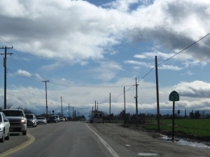
The first leg of the California High Speed Rail project will be located close to a long segment of California State Route 43. A look at the area reveals an interesting history with an uncertain future.
Route 43’s north end originates at its junction with State Route 99 in the farm town of Selma, about a dozen miles south of Fresno. Parallel to the Santa Fe Railroad right of way, the road exits town heading due south towards Hanford. Then the road bends east to nearly parallel State Route 99 through the town of Corcoran. Route 43 continues southeast past Colonel Allensworth State Historic Park and through the small Kern County towns of Wasco and Shafter. Finally, Route 43 turns due south again, crossing Interstate 5 southwest of Bakersfield. The road terminates at a desert intersection with State Route
At its northern origin, Route 43 passes through farms that appear to be prosperous. Where water flows, crops grow. The farther south one drives on Route 43, the drier the landscape becomes. By the end of the route, a desert dominates the land.
In the hot summers, where the road crosses a river or stream, healthy vegetation appears. Away from water sources, land without irrigation appears dry, dominated by drought tolerant plants.
Between Corcoran and Wasco, Colonel Allensworth State Historic Park is an abandoned settlement with no residents aside from park staff. The park is a restored farming village. The settlement was originally established by African Americans who wanted to form their own community, free of the prejudices sweeping the country in the late 1800’s.
Due to lack of adequate water and poor soil, the village ultimately failed. The park is a tribute to the brave efforts of a group that could only afford lesser productive land.
Desolation Ho!
As one proceeds south from the park on Route 43, the land appears drier, with less agricultural activity. Although farms operated at many locations along the route in the past, some have ceased operations. Lack of water is shriveling the industry.
Rivers and streams crossed by Route 43 can be dry any day of the year. Many water courses are empty in summer and fall. During drought, many fields lie fallow.
South of Wasco, someone unfamiliar with this part of the Valley may be surprised by areas of white alkali stretching as far as the eye can see. When people think of the San Joaquin Valley, they imagine farms with dairies, row crops, and orchards. This part of the valley looks like Death Valley.
The Towns of Route 43
Selma and Shafter serve mainly agriculture. The towns provide housing for farm labor, and have farm service businesses and food processing plants. Hanford also serves agriculture and has government jobs supported by the Lemoore Naval Air Station.
The towns of Corcoran and Wasco are each home to a state prison. The prisons provide good jobs that have kept the towns afloat during slumps in the agricultural economy.
South of Shafter on Route 43, no more towns inhabit the landscape. Dry open space dominates. Historical accounts of the southern end of the Great Valley indicate that a large lake once existed outside of Bakersfield. The Kern River once supported riverboat traffic and wild life was abundant.
The land supported agriculture until recent decades. As this part of California has dried up over time, the desert area has grown. Without imported water, the relentless drought would eventually make much of the southern Valley uninhabitable.
High Speed Rail to the Rescue?
What better way to create jobs than a large public works project? The first leg of California’s High Speed Rail project will connect Merced to Bakersfield. At a cost of billions of dollars, thousands of construction jobs will be created in an area mostly devoid of people who would use the transportation facility.
The route of the railway will depart Merced, travelling parallel to State Route 99 until it passes south of Fresno. It will jog south near Selma and loosely follow State Route 43 until it reaches Shafter. Then, the railway will turn east and coast into Bakersfield.
Usually carrying light traffic, Route 43 will be transformed into a bustling highway filled with railway construction traffic. The towns on Route 43 will experience an economic boom. While many workers will commute from Fresno and Bakersfield to construction sites, logistical support from the nearby towns will be needed.
Railroad’s Boost to the Economy
Many of the towns presently existing in the Central Valley were founded when Southern Pacific laid the original track in the 1880’s. The new high speed rail project could generate a comparable economic boom for cities in the Route 43 transportation corridor.
Whether or not the project will result in a permanent boost to the area economy remains to be seen. Depending on where maintenance facilities are located, permanent jobs could be created for train and track maintenance. Other types of jobs could blossom in towns that have station stops for the high speed trains.
All along Route 43, the availability of water for irrigation has declined due to drought over the past few decades. The agricultural boom of the past has drifted toward bust. With inadequate water, area farms are hardly sustainable. The high speed rail project may save the economy along the Route 43 corridor. In about 20 years, we will see the railway traverse either an economically prosperous region or a vastly expanded desert. The availability of water may be the deciding factor.

maybe the train can bring bottled water to this area???
LOL
sounds like the Pugs ( republicans ) have hijacked the train route to this unpopulated area to make it fail quickly…
we need to make the corporations that own the operating rail lines offer passenger services or pay more ,a lot more, in taxes for all that ( stolen Indian ) land
we gave them so long ago….