

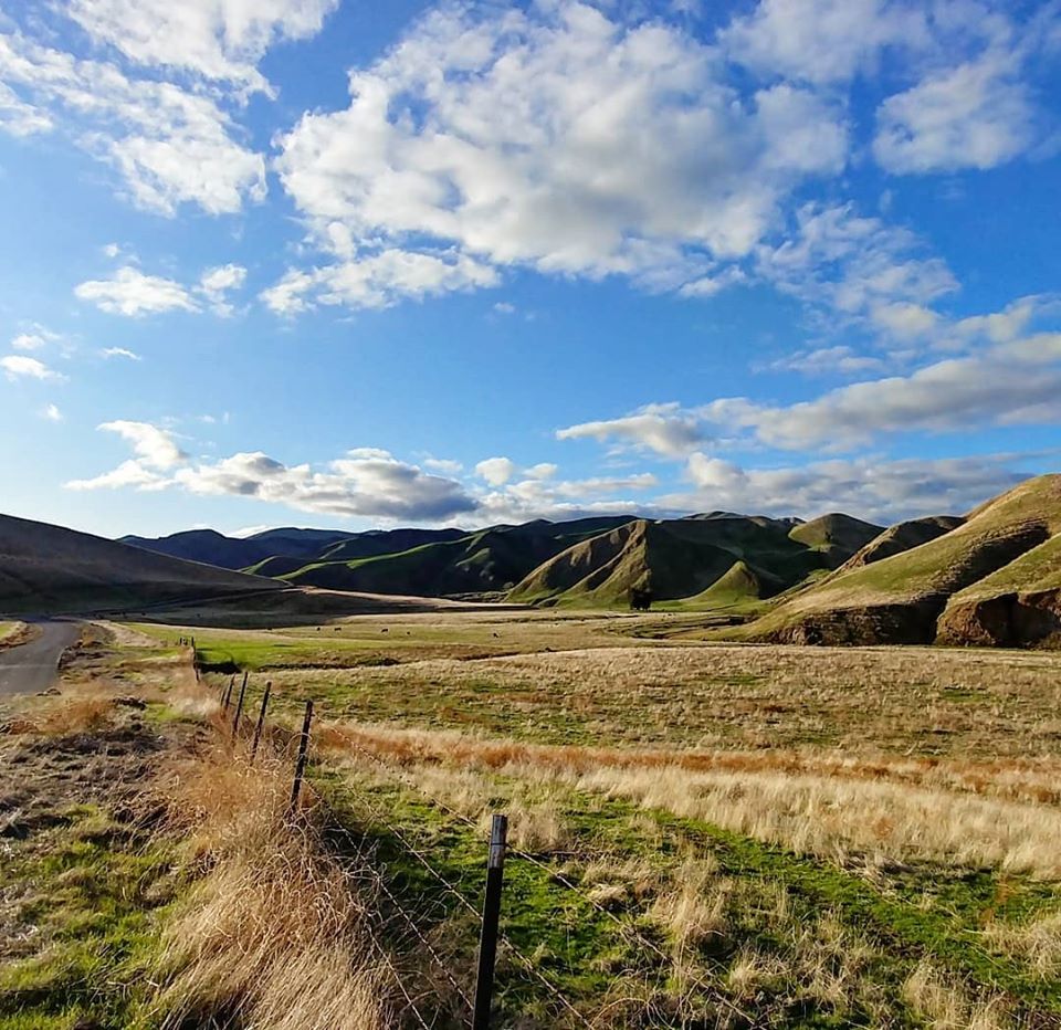
Nestled among the rolling hills of Northern California’s Diablo Range, along the western edge of the San Joaquin Valley, lies the narrow entrance to a unique canyon long known for its geological, biological, archaeological and paleontological significance.
Of late, however, Del Puerto Canyon is becoming better known for some very fast- tracked and heretofore little-known plans to build a 260 foot high dam and reservoir in an area with unstable seismic fault lines—but more on that later.
Del Puerto Canyon was named by Spanish explorers conducting their first inland traverse of the Central Valley en route to the San Francisco Bay Area in the late 1700s. They described the narrow rock opening in the mountain to the canyon beyond as, “Del Puerto,” meaning the doorway/entryway in Spanish.
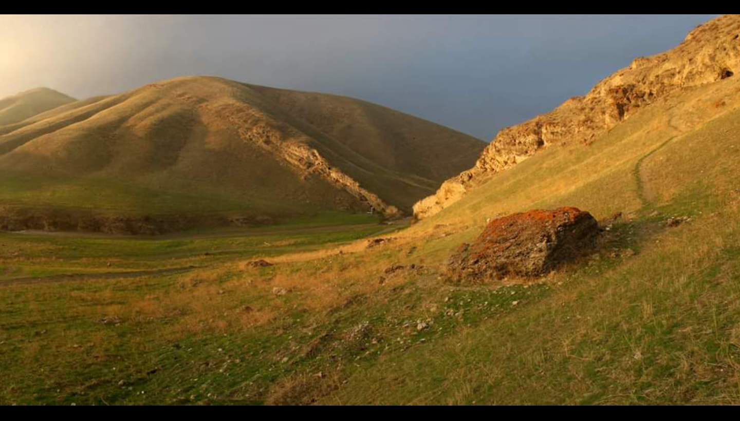
After entering through that historic gateway where Del Puerto Creek emerges, the first of Del Puerto Canyon’s intimate valleys opens up and an idea of the canyon’s scale can be sensed.
Flanked by steep rolling hills and colorful wildflowers in the spring, the first few miles of Del Puerto Canyon are among state’s most intriguing landscapes. There are bobcat and mountain lion sightings, one of the west’s largest golden eagle populations, remnant evidence of the endangered San Joaquin Kit Fox and Burrowing Owls, and badgers, among others.
Early Travelers
The Gateway and surrounding land once belonged to the Hoyumne and Miumne Yokuts Indians, who lived in this area and migrated between Del Puerto Canyon and the San Joaquin River. Evidence of their presence has been found up and down the canyon, as well as along the San Joaquin River, in the form of grinding rocks, cooking ovens, burial grounds, dwelling structures, and— maybe the most unique Native American evidence in West Stanislaus County—a prehistoric pathway carved into the Gateway rocks.
Handholds and steps, weathered away over the years, still exist on the Gateway rock feature once used to help the natives, Spanish explorers, Mexican horse wranglers, and American miners through this canyon.
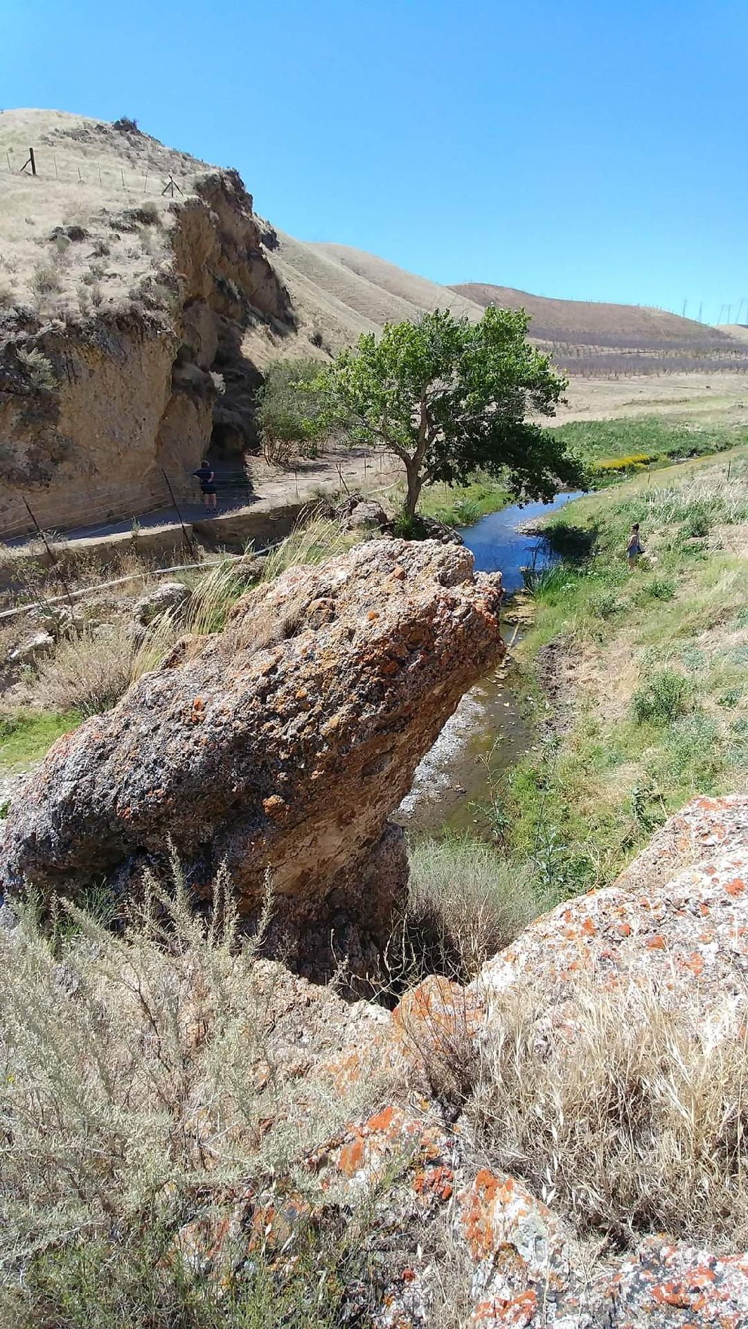
While Del Puerto Creek is currently perennial and gentle in nature, it at one time flowed as a strong river, giving more need for the pathway to be used to avoid its dangerous waters as it funneled through the Gateway narrows.
The rocks that make up the Gateway consist of exposed Coast Range Ophiolite, sediment that once was the seafloor off California’s coast before being tilted up and exposed during tectonic movement in the late Cenozoic era to present time.
Over time, the Coast Range Ophiolite was eroded away by the waters of the prehistoric Del Puerto Creek, carving the narrow opening to the valley that exists today. The days of large flows along the creek are now mostly gone, but there is still water to be found year round with many natural springs up and down the Del Puerto Creek watershed.
The most notable is Adobe Springs, about 18 miles up, known for its high flow of magnesium-rich water. Today, thousands of gallons of Adobe Springs water is shipped and sold daily to 7Up bottling in Modesto, but at one time it was a very important natural watering hole that natives and travelers alike relied upon.
The flowing artesian well was an important stop along “La Vereda de Montana” or “the Mountain Trail,” that was used by cross country Native American and Mexican travelers between Northern and Southern California who wanted to make their way through the Diablo Range undetected. The hidden trail through the lower Gateway and along Del Puerto Creek was a natural pathway that connected travelers with Adobe Springs, the San Antone Valley, and La Vereda Montana.
Indians looking to escape the coastal missions were also able to ditch Spanish search parties in the mazes of the mountains here, giving credence to their description of the mountains being “of the devil,” hence the name, “Diablo Range.” Tributaries of the canyon with names such as “Hideout Canyon,” “Murderer’s Gulch,” and others allude to their mysterious pasts.
Following the Spanish and Native American era in the canyon, Mexican horse drovers from Sonora Mexico—including the infamous Joaquin Murrieta—traveled through the Gateway from the 1820s when the land was Mexico, up until United States occupation in the early 1850s.These skilled horsemen utilized Del Puerto’s many “box” canyons to stash wild mustangs until gathering them for the annual drove of up to 300 head south through the mountain trail to the next watering hole, and eventually to their hometown in Sonora, Mexico where the healthy mustangs would be sold.
Geologic Importance and Magnesite Mining
In 1936, while exploring just within the entrance to the canyon, a curious young man from the nearby valley stumbled upon remains of animals that had been buried in the ground for millions of years. His name was Allan Bennison, and in 1936 he discovered what local legends claim are the first dinosaur bones to be found in California, those of the hind limbs of a Hadrosaur, buried since the late Cretaceous period.
A year later he found the skull of a Mosasaur. To call Del Puerto Canyon important geologically would be an understatement.
Remember the Coast Range Ophiolite that the Gateway is composed of? Those rocks were lifted and tilted by tectonic plate movement that affected the entire mountain range in a similar fashion.
So in essence, starting from the newest rocks nearest the earth’s surface beginning at the Gateway, and traveling west into Del Puerto Canyon, is a literal trip back in time past the era of the dinosaurs, through metamorphic layers, and up to where rocks and minerals from the earth’s mantle are exposed and resemble other worlds.
Geologists from all over have come to study Del Puerto Canyon for this very reason.
The first to really take advantage of the unique geology deep within the canyon were the magnesite miners of 1916. World War I had begun and there were only a few places in the U.S. where magnesite, needed for the war effort, could be mined, and it was found deep within Del Puerto Canyon.
Once located, engineers quickly began grading a path up the canyon for the narrow gauge Patterson and Western Railroad to traverse up to Jones Station, where the ore could be hauled out for processing.
They avoided the challenge of traversing Del Puerto Canyon’s narrow entrance by accessing the canyon from adjacent Black Gulch Canyon to the south.
From there, the natural path through the mountains created by Del Puerto Creek’s erosion was used to create the gradually ascending railroad grade to the magnesite mines. Utilizing Black Gulch Canyon (currently the I-5/Sperry Road interchange) also had its advantages because of its proximity to the recently incorporated City of Patterson, where the Sperry Road processing facility accessed the Southern Pacific Railway via a rail spur connecting to the narrow gauge railway.
By 1920, a few years after the end of the war, magnesite mining was no longer profitable, and by 1921 the two locomotives of the narrow gauge Patterson and Western Railroad were sold off to logging operations. When the rails of the railway were removed, a perfectly graded road bed was left where current day Del Puerto Canyon Road exists.
There are a few places where the road deviates from the historic Patterson and Western Railroad bed. Most of these locations are still visible within the first few miles of the canyon and would be inundated by the proposed Del Puerto Reservoir.
Recreation
The creation of the right of way through the canyon following the demise of the magnesite mining literally paved the way for modern day recreation in Del Puerto Canyon. The canyons of the Diablo Range had already been a popular destination for trappers and hunters, but with the development of the automobile, Del Puerto Canyon became the perfect destination for day trippers from Patterson going into the canyon for picnics.
To this day the 100 year old road grade is still used for recreational and educational access through the canyon. Frank Raines Park, Deer Creek OHV access, and the Minnear Day Use Area are popular recreational destinations established deeper in the canyon, but the first few miles of canyon have been historically associated with folks enjoying hikes and picnics by the creek.
For decades canyon ranchers allowed day use access on portions of creek front rangeland that remained unfenced. That access has diminished over the years, given increased illegal activity, including dumping, graffiti, off-roading, and shooting of livestock.
With the increase of illegal activity, more and more fences have gone up, even though the majority of people who continue to recreate in Del Puerto Canyon do so responsibly. Volunteers periodically conduct cleanups to help rid the area of excess refuse.
Given this continual use for recreation, the first few miles of Del Puerto Canyon have featured in the City of Patterson’s history since its founding. Destruction of this area with the creation of a dam and consequent inundation of the biological, geological, and archaeological resources would be a serious loss to the residents of Patterson, Stanislaus County and the state of California if the Del Puerto Water District goes through with its plans.
Not everything in Del Puerto Canyon would be lost if the dam and reservoir were built, only everything within the first five miles.
The Gateway—the natural feature for which it is named— would be utilized to help ease the construction of the proposed dam. Lead agency in this proposal, the Del Puerto Water District, would use the dam to shut the Gateway and store water within the first five miles of the Del Puerto Creek drainage, offering no recreational access to the area.
The historic roadway would have to be re-routed away from the proposed reservoir and connected to Diablo Grande Parkway.
The trees, the sacred Cottonwood trees which are the last living link to the Hoyumne and Miumne Yokuts, would be be cut down by order of the Stanislaus County Board of Supervisors.
If built, water from the Del Puerto Reservoir would envelop an area of the Del Puerto Creek drainage known to be some of the fastest eroding land in the state of California, with active landslides currently documented. Local geologist Garry Hayes and environmental compliance expert Dr. Tom Williams have both warned that studies for the possibilities of landslides are inadequate. Williams added recently,
“The geological formations and current topography are conducive to mass movements, slumps, and landslides at present and when their lower supporting slumps are wetted and lost strength to carry the loads of the ‘dry’ materials. Many landslides are waiting to happen when they get wet. Numerous slide/slumps may interfere with the efficient and reasonable storage and operations of the reservoir.”
The Del Puerto Water District’s plans also show its earthen dam situated almost directly along the San Joaquin Fault Line, which last broke in the 1860s with an estimated 6.0 magnitude earthquake.
The City of Patterson—which so far has chosen to remain relatively quiet about the dam—currently has plans showing growth and infrastructure in an area that would be in the dam’s inundation zone. The city’s general plan shows infrastructure supporting a population up to 55,000 people, including plans for a new I-5 interchange, right below the dam.
Interstate 5, the California Aqueduct and Delta Mendota Canals would be in danger of being washed away were there a catastrophic failure of the dam, not to mention losses of life by residents of Patterson.
Members of the Del Puerto Water District board have already said they are trying to fast track this project in order to take advantage of federal WIIN Act funding. In December, the water district released its draft Environmental Impact Report, shortly after announcing the beginning of the project in mid-2019.
Many years would be needed to accurately study the unique nature of Del Puerto Canyon—at the very least one full year of habitat and environmental study is in order. But for the Del Puerto Water District to claim they have an accurate study of the canyon after five months since inception of the project is absurd.
Though the City of Patterson has stayed relatively quiet about the dam, the City Parks and Recreation Department worked to produce documents in the Parks and Recreation Master Plan that called for preservation of the Gateway when development from the City of Patterson ensued.
What is being Done
The City Parks and Recreation Department, as well as previous city leaders have all recognized the Gateway as an area of great cultural and ecological significance and have called for preservation of the area with recreational access for horseback riding, hiking, mountain biking, as well as plans for an outdoor amphitheater.
Opposition to the proposed Del Puerto Reservoir is growing among those in Patterson who are becoming more aware of the hazards posed by the dam, as well as the potential for loss in property value and rise in insurance rates.
Those aware of Del Puerto Canyon’s unique beauty and special habitat have been chiming in from all over the country, appalled at the thought of losing this natural treasure.
Online and physical petition signatures have amassed over 2,000 within a short time frame and continue to gain support as those opposed to the dam continue to be heard among Water District, County, and City of Patterson meetings of elected officials.
Dam opponents anticipate a Feb. 25th presentation to the City of Patterson from the Del Puerto Water District regarding the proposed dam where they hope the City will take a stand against the dam.
What is not mentioned here is the City of Patterson against the advice of it’s own consultant and Planning Director included Del Puerto Canyon in its general.plan for housing and commercial development. Nothing would be worse to see the hills leveled and covered in concrete. The consultant and planning director brought up the environmental and other concerns with that plan. But the City Council went ahead anyone to.please a certain landowner and developer. Yet other than issues raised a few outside environmental groups there was silence. This sudden concern for the canyon rings hollow
Housing doesn’t cover with concrete . The “sudden” concern is related to the shocking fast track money grabbing useless dangerous plan to dam and lose Del Puerto Canyon .Are you making money off this??
Um, yes it does. What do you think these subdivisions rest on? Concrete and blacktop. And that land is still in Patterson’s General Plan. Where are these groups calling to ” Save ” Del Puerto Canyon calling for the city to remove land west of Hwy 5 from the General Plan? I am not making any money of the same. Money grabbing and useless? Do you have any idea what you are talking about? Apparently not.
Thank you, Del Puerto Canyon road as it is now laid out is a unique and rare access into a wild and beautiful place for the public. We in the Central Valley cannot even access Henry Coe State Park from the valley. Wrong place to put the water storage project. Safe and clean recharge of Patterson’s ground water can be done without losing lower Del Puerto Canyon.
Impressive reporting, Elias. Has The Modesto Bee reported on this important issue? Thank you for a comprehensive look at Diablo Canyon’s history.
This rainy season is shaping up as another dry year, aridity that’s part of our climate history. California developed most water policies 130 years ago on the heels of the Little Ice Age when Sierra glaciers were at their maximum extent. Del Puerto Water District plans to fill the dam during wet years, but the reality in our arid climate is the dam will probably hold back a fetid slough most years. Conservation is the only means to create a sustainable water ecology in California, and that means fallowing land that should have remained dryland farming and pasture.
We must look behind the stated reasons for building this dam. Primary among them is to deal with drought years which would deprive farmers of needed irrigation water. The dam, they say, would provide a “reserve” to be tapped during a drought. However, nowhere in the plans is there any means of maintaining the stored water as a true reserve. In fact, the most likely scenario is that there would be new plantings, probably of nut trees, plus conversion of older orchards. Because the trees would be thirstier, releases from the proposed dam would become necessary every year. If this scenario is not the case, then impose conditions on the dam that stored water can only be allocated to that acreage and those crops currently planted. You don’t use a reserve to buy new things, do you?
Steve: You are spot on. Are you working with these folks to help them bring their issues out in the publlic?
Richard Harriman
harrimanlaw1@sbclobal.net
The proposed Del Puerto Canyon Reservoir Project dam if built will jeopardize the entire city of Patterson California if it were to fail/ break/ have a catastrophic failure during an earthquake. This proposed dam project needs to be moved to an alternative site that does not put Patterson California at risk !! Why should the residents of Patterson have there lives and homes put in harms way so private land owners can sell water to southern California?! Why should Patterson California residents lives & homes be put at risk, so some greedy farmers can sell almonds to China?! Heck, none of this water will even go to the city of Patterson. This is unacceptable! We demand that this project in it’s current form is halted, & moved to an alternative site in the EIR Report that does not put Patterson California in harm’s way! These landowners/ farmers will need to find a new location to store water that will not put the city of Patterson in jeopardy of being wiped off the map…
Click the link to see what could happen to Patterson California if the dam breaks…
https://makeameme.org/meme/del-puerto-canyon-ca4d442749?fbclid=IwAR38RXag5Mq_FTFEt4EdwJN51p8mLnTk3IgALHWzdNq-q-r-qXNoBOhUpJQ
THE DAM MUST BE MOVED!!!
The proposed Del Puerto Canyon Reservoir Dam Project can be built at an alternative site that does not put Patterson California in harm’s way, it will be a win for Patterson & a win for Farmers….
Click the link to see the available alternative sites listed in the Del Puerto Canyon Reservoir Project EIR Report… 🤔
https://makeameme.org/meme/the-dam-must
“Groups criticize Del Puerto Canyon Reservoir site, environmental report
On Monday, January 27, Friends of the River, Save Del Puerto Canyon, California Water Research, and environmental and fishing groups filed comments highly critical of the Del Puerto Canyon Reservoir proposed site and the project’s Draft Environmental Impact Report.”
“Friends of the River’s senior advocate, Ron Stork, joined Modesto area geologist Garry Hayes and geologist / environmental compliance expert, Dr. Tom Williams, in expressing concerns about the reservoir inundating an area with active landslides. Stork is widely recognized for warning the California Department of Water Resources of the potential failure modes of the Oroville dam emergency spillway.”
https://www.google.com/amp/s/cah2oresearch.com/2020/01/30/groups-criticize-del-puerto-canyon-reservoir-site-environmental-report/amp/
Click the link & sign the petition…
No Del Puerto Canyon Reservoir Project Dam…
https://actionnetwork.org/petitions/no-del-puerto-canyon-reservoir
1/21/2020 Patterson California City council meeting, packed house, residents address council (for over an hour) in opposition of the proposed Del Puerto Canyon Reservoir Project Dam… Click the link to see & hear for yourself…
https://vimeo.com/386406905?outro=1&ref=fb-share&fbclid=IwAR1m8VuIkMIssFk7T84dz_Zp6G9h5eZqqmupWhDkRbAvaekdUviK_WrjW7w
`All risks and no reward`: Patterson group fights back against proposed dam
Fox 40 news in Patterson California, MSN picks up story!
Click the link & watch the Fox 40 news Report…
https://www.msn.com/en-us/Weather/peopleandplaces/all-risks-and-no-reward-patterson-group-fights-back-against-proposed-dam/vi-BBZ4Q8G?ocid=sf2
The dam builders are active throughout California where they think they can get public money. They don’t give a hoot about the environment. If the project will make money for their cronies, they will try to justify it. Another Dam is proposed for Los Banos Creek, south of San Luis Reservoir. The proposed dam would hold about the same amount of water as San Luis. It would also cover a scenic canyon with Native American artifacts in an area with earthquake faults. There is a historical trail called “Path of the Padres” that follows the creek. It is a great place to visit in the spring.
Beautiful pictures
But there’s one problem.
He is on posted private property.
Isn’t that against the law?
ST: He had permission to be on the property.
Thanks for this write up, Elias. Good job. Enjoyed meeting you the night of the public meeting on 1/20 and I appreciate your civic involvement. Keith makes an outstanding point when he states, “Conservation is the only means to create a sustainable water ecology in California, and that means fallowing land that should have remained dryland farming and pasture.” Looking forward, I think this is really where the focus needs to be in our arid environment.
Great article, Elias. Thanks and thank you, Eric, for making this possible.
Since 1980 I have been taking a break from my hectic life to enjoy the nature and especially the wildlife in Del Puerto Canyon. The Blue Grosbeak, Grasshopper Sparrow and Burrowing Owls were always looked for at certain times of the year, soon after I left Highway 5 headed up Del Puerto Canyon Road. One special trip I recall, probably in spring or early summer when I had spotted Burrowing Owls in the past on the hillside less than one mile up Del Puerto Canyon Road, I stopped to look for the Burrowing Owls on the hillside. My birding friend and I noticed a four legged animal waddling up the side of the hill, which we soon realized was a badger. My first and only one I have ever seen! I turned off my car engine and we watched it with our binocs. As it made a circle on the hillside we watched this one badger go to a squirrel hole, put its rear end in the hole, then shake, then waddle up and move around the hillside to do the same procedure several times. We were shocked when it came full circle and crossed the road in front of my car to proceed across the road, up a road cutout, go under a fence and then start digging (we watched the dirt fly) but couldn’t follow it anymore.
Just up the road we saw the removal of vegetation and turning over of the soil. Our speculation was this animal possibly had a home there and was moved to the hillside below and was now marking its territory.
Later we saw an orchard had been planted on the hillside which had been cleared, with some places where trees had been planted among outcroppings of rocks. But now the orchard is abandoned. Before the land was cultivated and the orchard was planted, I was told this land was to become part of the Patterson City.
Is this dead orchard now a part of the city?
Thanks again, Elias, for a great article. My escape to places like Del Puerto has comforted me in my turbulant life. I am grateful for the opportunity to be in nature. This Del Puerto Canyon is a special place.
Hi Elias.
Nice piece.
Who owns the water bottling plant out of Modesto, Gallo? And how did they get those water rights?
Thanks
The bottled water, They buy the water from Adobe Springs.
The owner shares it, free to the public if you take your containers up to the spring.
The most amazing water ! #mothernatureismychurch
Del Puerto Canyon is great, been going up to my families place since I can remember. The only bad part is all the losers who spray paint all over the place. I recently saw some losers doing it and they look like Bay Area Trash. Patterson is a dump now due to the Bay Trash moving in.
Experienced Patterson and the canyon in the mid-1970s. In the 1980s would trek from Modesto to hike the canyon. Great memories. So very sad that the urban riff-raff invaded and are destroying a once-pristine area.
Great article. The reservoir would be disaster for many reasons. I need, most respectfully, to correct some geology though: the historic doorway in Elias’s beautiful photo is not made of Coast Range Ophiolite, which crops out miles upstream. The rocks here are much younger and have nothing to do with the CRO. They have their own wonderful stories though. The rock sequence in the hills that descend to this portal to the old El Camino Viejo includes the Oligocene (ca. 30 my old) Valley Springs Formation, which erupted as an ash-flow tuff from a caldera in central Nevada. It is the subject of focused investigation by numerous researchers.
Stephen W. Edwards, Ph.D., geologist and botanist with a lifetime of experience in Del Puerto Canyon…
… [Trackback]
[…] Read More: thevalleycitizen.com/del-puerto-canyon-then-and-now-a-controversy/ […]
… [Trackback]
[…] Info to that Topic: thevalleycitizen.com/del-puerto-canyon-then-and-now-a-controversy/ […]
… [Trackback]
[…] Info on that Topic: thevalleycitizen.com/del-puerto-canyon-then-and-now-a-controversy/ […]
A lot of nice land for some trails mountain biking, hiking, that would get more people involved in fighting to preserve it, but all the graffiti just comes to show that people really don’t care about this place.
Lino,
You make a good point. And, the area where there is graffiti are on rocks that are not only dangerous to climb, but on a corner.
This was the first time I have been through, but the majority is very nice–and a perfect place for people to see last years fire damage. I think the majority of people care, but for those who need to get a clue, quit throwing your glass beer bottles on the side of the road.
Mellisa
Del Puerto Canyon: Then and Now, a Controversy
read the article
Del Puerto Canyon: Then and Now, a Controversy
Jenifer
Del Puerto Canyon: Then and Now, a Controversy
Elias Looking to buy Photo of del puerto canyon. Please contact me at (209) 895-0657
According this this story – https://thebeatlesneverbrokeup.com/story/
there is a portal to another dimension in Del Puerto Canyon, where a
Beatles album was recorded in a world where they didn’t break up.
The album – Everyday Chemistry – is forever a part of Del Puerto!
The album is on You Tube at: https://www.youtube.com/watch?v=ty8zaBS4Bjg
Comments are closed.